![](/images/other/stat-length.png)
![Excursión Senderismo Sankt Vith - RF-Lg-15_Recht_Grande-boucle - Photo](https://media.geolcdn.com/t/1900/400/ext.pjpeg?maxdim=2&url=https%3A%2F%2Fstatic1.geolcdn.com%2Fsiteimages%2Fupload%2Ffiles%2F1553511878bg_sport_marche.png)
RF-Lg-15_Recht_Grande-boucle
GR Rando
Randonnez sur et autour des GR ® wallons (Sentiers de Grande Randonnée). PRO
![Longitud](/images/other/stat-length.png)
![Altitud máxima](https://static1.geolcdn.com/siteimages/upload/files/1508320355ic_sort_altitude_max_24dp.png)
![Desnivel positivo](https://static1.geolcdn.com/siteimages/upload/files/1508320355ic_sort_den_pos_24dp.png)
![Km-Effort](/images/other/stat-length.png)
![Altitud mínima](https://static1.geolcdn.com/siteimages/upload/files/1508320355ic_sort_altitude_min_24dp.png)
![Desnivel negativo](https://static1.geolcdn.com/siteimages/upload/files/1508320355ic_sort_den_neg_24dp.png)
![Boucle](https://static1.geolcdn.com/siteimages/upload/files/16400158638029165_repeat_loop_refresh_sync_direction_icon.png)
![Senderismo](https://static1.geolcdn.com/sitytour/trail-icons/101.png)
3h39
Dificultad : Desconocido
![Escanee este código QR para abrir la excursión en la aplicación SityTrail](https://capi.geolives.com/qq0zvz2zws4bq2lad0pu/sitytour/trails/420188/qr.png?size=200)
Aplicación GPS de excursión GRATIS
A propósito
Ruta Senderismo de 12 km a descubrir en Valonia, Lieja, Sankt Vith. Esta ruta ha sido propuesta por GR Rando.
Descripción
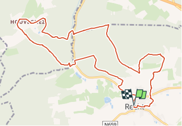
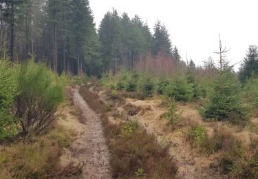
RF-LG-15 - En zigzaguant dans la vallée du Rechterbach.
Dans quel type de paysage randonnons-nous?
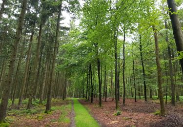
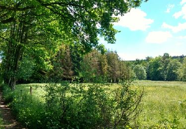
En traversant deux fois le Rechterbach (ruisseau de Recht) et en gravissant les deux versants de la vallée, nous aurons tout loisir d’admirer les paysages de pâtures et de bois, très vallonnés, voire escarpés, qui dominent le village de Recht.
Difficulté ?
Cette balade peut être considérée comme relativement ardue. Les pentes raides se succèdent.
Combien de kilomètres ?
12,1 km.
Sur quel GR randonnons-nous ?
La partie initiale de la balade emprunte le GR 56 «Cantons de l’Est et parc naturel “Hautes-Fagnes – Nord-Eifel”».
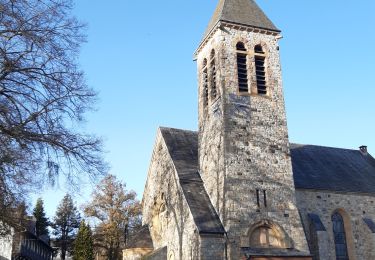
Où démarrons-nous ?
À l’église de Recht (carte Michelin n° 534, pli V/20) (grand parking).
Comment y arriver ?
Par la N660 (Ligneuville – Recht) ou la N659 (Amel (Amblève) – Recht).
Que découvrons-nous aujourd’hui ?
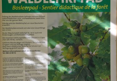
À Recht, nous pourrons visiter une galerie souterraine où, il n’y a pas si longtemps, on extrayait encore une sorte de schiste qui n’était pas destiné à la fabrication d’ardoises ou de lauzes : la pierre bleue.
À quelques kilomètres de Recht, le musée Poteau ’44 nous fera revivre un épisode tragique de la bataille des Ardennes.
Quelle est la carte IGN de référence ?
Carte IGN au 1:20 000 : «Vielsalm – Recht», 56/1-2.
Transports en commun ?
Aucun à une heure utile.
Localización
Comentarios
Excursiones cerca
![Excursión Senderismo Sankt Vith - 2021-05-17_18h38m48_recht - Photo](https://media.geolcdn.com/t/375/260/df57db6f-82de-45d3-a1f9-f0242505f9de.jpg&format=jpg&maxdim=2)
![Senderismo Senderismo](https://static1.geolcdn.com/sitytour/trail-icons/101.png)
Senderismo
![](/images/other/stat-length.png)
![](https://static1.geolcdn.com/siteimages/upload/files/16400158638029165_repeat_loop_refresh_sync_direction_icon.png)
![Excursión Senderismo Malmedy - ligneuville - ondeval aller retour - Photo](https://media.geolcdn.com/t/375/260/5d217ee2-30bd-4bc8-82e6-a4da860aa974.jpg&format=jpg&maxdim=2)
![Senderismo Senderismo](https://static1.geolcdn.com/sitytour/trail-icons/101.png)
Senderismo
![](/images/other/stat-length.png)
![](https://static1.geolcdn.com/siteimages/upload/files/16400158638029165_repeat_loop_refresh_sync_direction_icon.png)
![Excursión Patinaje Malmedy - Vallée de l'Amblève - Photo](https://media.geolcdn.com/t/375/260/ext.jpg?maxdim=2&url=https%3A%2F%2Fservices.sitytrail.com%2FGeolivesWS%2FDownloadMedia.ashx%3FTrailID%3D767158%26Media%3Dfix__20170605123453.jpg)
![Patinaje Patinaje](https://static1.geolcdn.com/sitytour/trail-icons/901.png)
Patinaje
![](/images/other/stat-length.png)
![](https://static1.geolcdn.com/siteimages/upload/files/16400158638029165_repeat_loop_refresh_sync_direction_icon.png)
![Excursión Senderismo Sankt Vith - Rodt - Chiens de traineau - Photo](https://media.geolcdn.com/t/375/260/1e66ffeb-aa18-4dc8-9647-91e8788c7358.jpg&format=jpg&maxdim=2)
![Senderismo Senderismo](https://static1.geolcdn.com/sitytour/trail-icons/101.png)
Senderismo
![](/images/other/stat-length.png)
![](https://static1.geolcdn.com/siteimages/upload/files/16400158638029165_repeat_loop_refresh_sync_direction_icon.png)
![Senderismo Senderismo](https://static1.geolcdn.com/sitytour/trail-icons/101.png)
Senderismo
![](/images/other/stat-length.png)
![](https://static1.geolcdn.com/siteimages/upload/files/16400158638029165_repeat_loop_refresh_sync_direction_icon.png)
![Excursión A pie Stavelot - 4. Promenade de l'Ecureuil - Photo](https://media.geolcdn.com/t/375/260/a994dd92-9fdf-4425-832e-ec7cd6a4ee8b.jpeg&format=jpg&maxdim=2)
![A pie A pie](https://static1.geolcdn.com/sitytour/trail-icons/100.png)
A pie
![](/images/other/stat-length.png)
![](https://static1.geolcdn.com/siteimages/upload/files/16400158638029165_repeat_loop_refresh_sync_direction_icon.png)
![Excursión A pie Trois-Ponts - Liaison - Photo](https://media.geolcdn.com/t/375/260/e76f3a7b-19a9-4fd4-95e5-f56c159ed203.jpeg&format=jpg&maxdim=2)
![A pie A pie](https://static1.geolcdn.com/sitytour/trail-icons/100.png)
![Excursión Senderismo Sankt Vith - Recht 22 km - Photo](https://media.geolcdn.com/t/375/260/a9f794ab-d5e8-4cf0-8525-510ce3401da7.jpeg&format=jpg&maxdim=2)
![Senderismo Senderismo](https://static1.geolcdn.com/sitytour/trail-icons/101.png)
![Excursión Senderismo Stavelot - Refat 17,3km - Photo](https://media.geolcdn.com/t/375/260/ext.jpg?maxdim=2&url=https%3A%2F%2Fstatic1.geolcdn.com%2Fsiteimages%2Fupload%2Ffiles%2F1553511878bg_sport_marche.png)
![Senderismo Senderismo](https://static1.geolcdn.com/sitytour/trail-icons/101.png)
Senderismo
![](/images/other/stat-length.png)
![](https://static1.geolcdn.com/siteimages/upload/files/16400158638029165_repeat_loop_refresh_sync_direction_icon.png)